| dc.contributor.author | Buhl-Mortensen, Lene | |
| dc.contributor.author | Buhl-Mortensen, Pål | |
| dc.date.accessioned | 2010-03-22T15:16:32Z | |
| dc.date.issued | 2008 | |
| dc.identifier.issn | 0804-5496 | |
| dc.identifier.issn | 0808-1522 | |
| dc.identifier.uri | http://hdl.handle.net/11250/116967 | |
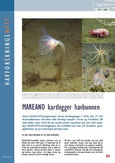
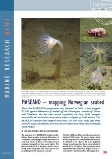
| dc.description.abstract | Since the MAREANO programme was initiated in 2006, it has mapped 37 000 square kilometres of seabed off the Norwegian counties of Troms and Nordland. On the most recent expedition in June 2008, samples were collected and videos were taken down to depths of 2000 metres. The MAREANO project has mapped more than 330 new coral reefs, gas seeps and new deep-sea habitats, and has also developed procedures for predicting nature types. | en |
| dc.format.extent | 477193 bytes | |
| dc.format.extent | 482098 bytes | |
| dc.format.mimetype | application/pdf | |
| dc.format.mimetype | application/pdf | |
| dc.language.iso | eng | en |
| dc.publisher | Havforskningsinstituttet | en |
| dc.relation.ispartofseries | Havforskningsnytt | en |
| dc.relation.ispartofseries | Nr. 4 - 2008 | en |
| dc.relation.ispartofseries | Marine research news | en |
| dc.relation.ispartofseries | No. 4 - 2008 | en |
| dc.title | MAREANO kartlegger havbunnen : MAREANO – mapping Norwegian seabed | en |
| dc.type | Working paper | en |
| dc.subject.nsi | VDP::Mathematics and natural science: 400::Geosciences: 450::Oceanography: 452 | en |
| dc.subject.nsi | VDP::Mathematics and natural science: 400::Zoology and botany: 480::Marine biology: 497 | en |
| dc.subject.nsi | VDP::Agriculture and fishery disciplines: 900::Fisheries science: 920 | en |
| dc.source.pagenumber | 2 s. | en |