• norsk
    • English
  • English 
    • norsk
    • English
  • Login
View Item 
  •   Home
  • Havforskningsinstituttet
  • Research Programmes
  • MAREANO
  • View Item
  •   Home
  • Havforskningsinstituttet
  • Research Programmes
  • MAREANO
  • View Item
JavaScript is disabled for your browser. Some features of this site may not work without it.

MAREANO kartlegger havbunnen : MAREANO – mapping Norwegian seabed

Buhl-Mortensen, Lene; Buhl-Mortensen, Pål
Working paper
Thumbnail
View/Open
Norsk versjon (466.0Kb)
English version (470.7Kb)
URI
http://hdl.handle.net/11250/116967
Date
2008
Metadata
Show full item record
Collections
  • MAREANO [30]
Abstract
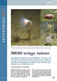
Since the MAREANO programme was initiated in 2006, it has mapped 37 000 square kilometres of seabed off the Norwegian counties of Troms and Nordland. On the most recent expedition in June 2008, samples were collected and videos were taken down to depths of 2000 metres. The MAREANO project has mapped more than 330 new coral reefs, gas seeps and new deep-sea habitats, and has also developed procedures for predicting nature types.
Publisher
Havforskningsinstituttet
Series
Havforskningsnytt
Nr. 4 - 2008
Marine research news
No. 4 - 2008

Contact Us | Send Feedback

Privacy policy
DSpace software copyright © 2002-2019  DuraSpace

Service from  Unit


Browse

ArchiveCommunities & CollectionsBy Issue DateAuthorsTitlesSubjectsDocument TypesJournalsThis CollectionBy Issue DateAuthorsTitlesSubjectsDocument TypesJournals

My Account

Login

Statistics

View Usage Statistics

Contact Us | Send Feedback

Privacy policy
DSpace software copyright © 2002-2019  DuraSpace

Service from  Unit